
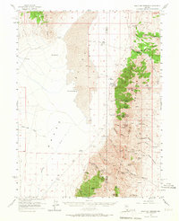
1956 Map of Walti Hot Springs
USGS Topo · Published 1957About this map
The Simpson Park Range dominates this mid-century survey of the Lander and Eureka county line, where high-altitude peaks like McClusky Peak and Fagin Mtn look down upon the expansive Grass Valley. This arid landscape is defined by its vital water sources, ranging from the thermal waters at Hot Springs and Little Hot Springs to a network of isolated tanks and springs supporting local livestock operations. Settlement is concentrated around established outposts such as Walti Ranch, Allen Ranch, and Baumann Ranch, connected by primitive jeep trails that navigate the steep breaks of Moonshine Canyon and Potato Canyon. The map records the intersection of resource extraction and ranching life, notably at the Keystone Mine and the appropriately named Cowboy Rest along Callaghan Creek.
Find a feature on this map
52 named features on this map. Tap any name to fly to it.
Don’t see what you’re looking for? This feature index may not catch every label — zoom into the map to look around manually.
Map Details
Editions of this 1956 Walti Hot Springs Map
2 editions found
Other maps of this area

1926 · Roberts Mountains
USGS Topo · 1:250,000

1929 · Roberts Mountains
USGS Topo · 1:250,000

1938 · Cortez
USGS Topo · 1:48,000

1944 · Cortez
USGS Topo · 1:62,500

1949 · Roberts Creek Mtn
USGS Topo · 1:62,500

1951 · Roberts Creek Mtn
USGS Topo · 1:62,500

1955 · Millett
USGS Topo · 1:250,000

1955 · Winnemucca
USGS Topo · 1:250,000

1956 · Bartine Ranch
USGS Topo · 1:62,500

1956 · Mount Callaghan
USGS Topo · 1:62,500