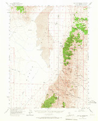
1956 Map of Walti Hot Springs
USGS Topo · Published 1971About this map
Walti Ranch and Allen Ranch anchor this mid-century survey of the high desert along the border of Lander and Eureka counties. The landscape is defined by the sharp contrast between the broad expanse of Grass Valley and the steep elevations of the Simpson Park Mountains. The presence of Hot Springs and Little Hot Springs indicates the geothermal activity that names this quadrangle, while numerous isolated water sources like Rye Patch Spring and Crystal Spring dictate the patterns of ranching and movement through the basin.
Find a feature on this map
50 named features on this map. Tap any name to fly to it.
Don’t see what you’re looking for? This feature index may not catch every label — zoom into the map to look around manually.
Map Details
Editions of this 1956 Walti Hot Springs Map
2 editions found

Other maps of this area

1926 · Roberts Mountains
USGS Topo · 1:250,000

1929 · Roberts Mountains
USGS Topo · 1:250,000

1938 · Cortez
USGS Topo · 1:48,000

1944 · Cortez
USGS Topo · 1:62,500

1949 · Roberts Creek Mtn
USGS Topo · 1:62,500

1951 · Roberts Creek Mtn
USGS Topo · 1:62,500

1955 · Millett
USGS Topo · 1:250,000

1955 · Winnemucca
USGS Topo · 1:250,000

1956 · Bartine Ranch
USGS Topo · 1:62,500

1956 · Mount Callaghan
USGS Topo · 1:62,500