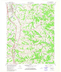
1981 Map of Walton
USGS Topo · Published 1982About this map
The rolling landscape where Boone, Kenton, Grant, and Pendleton Counties meet is defined by the headwaters of Cruisers Creek and the North Fork of the Licking River. In the early 1980s, this area reflects a rural character undergoing change as Interstate 75 corridors flank long-standing settlements like Walton and Crittenden. The geography is notable for its dense concentration of family burial grounds, including Byland Cem, Northcutt Cem, and Peoples Cem, which are scattered among the ridges and hollows, providing significant data for genealogical research.
Find a feature on this map
58 named features on this map. Tap any name to fly to it.
Don’t see what you’re looking for? This feature index may not catch every label — zoom into the map to look around manually.
Map Details
Editions of this 1981 Walton Map
2 editions found
Other maps of this area

1929 · Alexandria
USGS Topo · 1:48,000

1930 · Falmouth
USGS Topo · 1:48,000

1936 · Alexandria
USGS Topo · 1:62,500

1936 · Falmouth
USGS Topo · 1:62,500

1950 · Elliston
USGS Topo · 1:24,000

1950 · Union
USGS Topo · 1:24,000

1950 · Williamstown
USGS Topo · 1:24,000

1950 · Independence
USGS Topo · 1:24,000

1950 · Verona
USGS Topo · 1:24,000

1950 · Walton
USGS Topo · 1:24,000