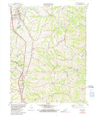
1981 Map of Walton
USGS Topo · Published 1991About this map
Walton and Crittenden anchor this northern Kentucky landscape at the junction of several county boundaries, including Boone, Kenton, Grant, and Pendleton. The map captures a transition where the expanding transportation corridor of Interstate 71 and the Southern railroad cut through traditional ridge-and-hollow topography. This area is notably dense with small family and community burial grounds, such as Byland Cem, Northcutt Cem, and Sayers Cem, reflecting the deep-rooted genealogical history of the surrounding rural settlements like Bracht and Piner. Large conservation and recreation tracts, specifically the Curtis Gates Lloyd Wildlife Area and Mullins Wildlife Area, dominate the southern and central sections, preserving the drainage basins of Bullock Pen Creek and Grassy Creek. Significant local institutions, including St Joseph Academy and Walton-Verona High Sch, indicate the region's role as a social and educational hub for the tri-county area.
Find a feature on this map
63 named features on this map. Tap any name to fly to it.
Don’t see what you’re looking for? This feature index may not catch every label — zoom into the map to look around manually.
Map Details
Editions of this 1981 Walton Map
2 editions found
Other maps of this area

1929 · Alexandria
USGS Topo · 1:48,000

1930 · Falmouth
USGS Topo · 1:48,000

1936 · Alexandria
USGS Topo · 1:62,500

1936 · Falmouth
USGS Topo · 1:62,500

1950 · Elliston
USGS Topo · 1:24,000

1950 · Union
USGS Topo · 1:24,000

1950 · Williamstown
USGS Topo · 1:24,000

1950 · Independence
USGS Topo · 1:24,000

1950 · Verona
USGS Topo · 1:24,000

1950 · Walton
USGS Topo · 1:24,000