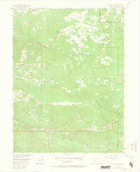
1956 Map of Walton Peak
USGS Topo · Published 1965About this map
Walton Peak serves as a prominent landmark on this mid-century survey, sitting at an elevation over 10,500 feet along the high ridges of the Gore Range. The map documents a landscape defined by the intersection of the Routt National Forest and the Arapaho National Forest, with the Routt and Grand County line cutting across the eastern slopes. This high-country terrain is characterized by a dense network of water sources, including numerous Beaver Ponds and the headwaters of Muddy Creek, Green Creek, and Service Creek. Transportation in this era was limited to fundamental foot and pack routes, including the Buffalo Park Trail and the Service Creek Trail, which provided access to these remote watersheds before modern road development expanded into the backcountry.
Find a feature on this map
18 named features on this map. Tap any name to fly to it.
Don’t see what you’re looking for? This feature index may not catch every label — zoom into the map to look around manually.
Map Details
Editions of this 1956 Walton Peak Map
4 editions found
Other maps of this area

1954 · Craig
USGS Topo · 1:250,000

1956 · Rabbit Ears Peak
USGS Topo · 1:24,000

1956 · Lake Agnes
USGS Topo · 1:24,000

1956 · Storm Mountain
USGS Topo · 1:24,000

1956 · Walton Peak
USGS Topo · 1:24,000

1956 · Gore Pass
USGS Topo · 1:62,500

1956 · Rabbit Ears Peak
USGS Topo · 1:62,500

1957 · Craig
USGS Topo · 1:250,000

1958 · Craig
USGS Topo · 1:250,000

1960 · Craig
USGS Topo · 1:250,000