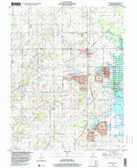
1998 Map of Waltonville
USGS Topo · Published 2000About this map
Rend Lake dominates the eastern edge of this Jefferson County landscape, where the Rend Lake State Waterfowl Management Area marks a significant intersection of conservation and water management. To the west, the village of Waltonville serves as a central hub for the surrounding rural townships of Blissville, McClellan, and Elk Prairie. The terrain is characterized by a high concentration of small family and community burial grounds, including Gilbert Cem and Dryden Cem, alongside local spiritual centers like St Barbara Ch and Oakland Ch. Industrial and agricultural footprints are evident through several large Tailings Ponds near the lake and scattered Oil Wells. The map captures the quiet persistence of crossroads settlements such as Scheller and Emerson City at the close of the 20th century, before modern development further altered the drainage patterns of Knob Prairie Creek and Hurricane Creek.
Find a feature on this map
42 named features on this map. Tap any name to fly to it.
Don’t see what you’re looking for? This feature index may not catch every label — zoom into the map to look around manually.
Map Details
Editions of this 1998 Waltonville Map
This is the sole edition of this map. No revisions or reprints were ever made.
Other maps of this area

1926 · Duquoin
USGS Topo · 1:62,500

1933 · Mount Vernon
USGS Topo · 1:48,000

1939 · Ina
USGS Topo · 1:62,500

1940 · Mount Vernon
USGS Topo · 1:62,500

1943 · Ina
USGS Topo · 1:62,500

1943 · Ashley
USGS Topo · 1:62,500

1946 · Ashley
USGS Topo · 1:62,500

1958 · Belleville
USGS Topo · 1:250,000

1962 · Belleville
USGS Topo · 1:250,000
1965 · Mount Vernon
USGS Topo · 1:24,000