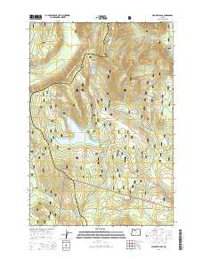
2014 Map of Wapinitia Pass
USGS Topo · Published 2014About this map
Wapinitia Pass and Blue Box Pass serve as the primary gateways through this high-altitude section of the Mount Hood National Forest on the border of Clackamas and Wasco counties. The landscape is defined by its strategic transportation corridors, where the modern Warm Springs Hwy follows ancient routes past Frog Lake and Clear Lake. Of particular interest to historians is the presence of the Barlow Rd, a historic overland route that provided a bypass for travelers on the Oregon Trail. Higher elevations are marked by Frog Lake Buttes and Mud Creek Ridge, while the Pacific Crest National Scenic Trail traverses the ridgelines near the Salmon River headwaters. The map also captures several forest service arteries like Oregon Skyline Rd and the Frog Cr Ditch, reflecting the region's managed timber and water resources.
Find a feature on this map
45 named features on this map. Tap any name to fly to it.
Don’t see what you’re looking for? This feature index may not catch every label — zoom into the map to look around manually.
Map Details
Editions of this 2014 Wapinitia Pass Map
This is the sole edition of this map. No revisions or reprints were ever made.
Other maps of this area

1924 · Mount Hood
USGS Topo · 1:125,000

1927 · Mount Hood
USGS Topo · 1:125,000

1953 · The Dalles
USGS Topo · 1:250,000

1956 · The Dalles
USGS Topo · 1:250,000

1956 · High Rock
USGS Topo · 1:62,500

1956 · Mt. Wilson
USGS Topo · 1:62,500

1957 · The Dalles
USGS Topo · 1:250,000
1962 · Badger Lake
USGS Topo · 1:24,000
1962 · Government Camp
USGS Topo · 1:24,000
1962 · Timberline Lodge
USGS Topo · 1:24,000