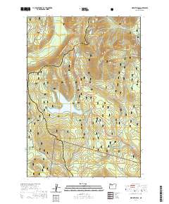
2020 Map of Wapinitia Pass
USGS Topo · Published 2020About this map
Wapinitia Pass serves as a critical mountain corridor where the Clackamas Co Wasco Co line follows the crest of the Cascades. This high-country landscape is defined by its transition from the wet western slopes of Mount Hood National Forest to the drier eastern drainage. The map reveals a complex network of seasonal routes, including the Pacific Crest National Scenic Trail and specialized winter corridors like the Mud Creek Loop Nordic and Timothy Lake/High Rocks Snowmo tracks.
Find a feature on this map
33 named features on this map. Tap any name to fly to it.
Don’t see what you’re looking for? This feature index may not catch every label — zoom into the map to look around manually.
Map Details
Editions of this 2020 Wapinitia Pass Map
This is the sole edition of this map. No revisions or reprints were ever made.
Other maps of this area

1924 · Mount Hood
USGS Topo · 1:125,000

1927 · Mount Hood
USGS Topo · 1:125,000

1953 · The Dalles
USGS Topo · 1:250,000

1956 · The Dalles
USGS Topo · 1:250,000

1956 · High Rock
USGS Topo · 1:62,500

1956 · Mt. Wilson
USGS Topo · 1:62,500

1957 · The Dalles
USGS Topo · 1:250,000
1962 · Badger Lake
USGS Topo · 1:24,000
1962 · Government Camp
USGS Topo · 1:24,000
1962 · Timberline Lodge
USGS Topo · 1:24,000