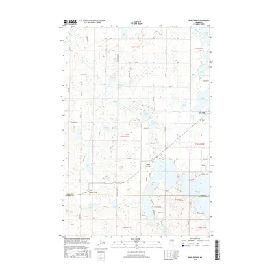
2016 Map of Ward Springs
USGS Topo · Published 2016About this map
Ward Springs and the village of Grey Eagle anchor this central Minnesota landscape, where the glacial legacy is evident in a dense network of lakes and wetlands. The map details the transition between Todd and Stearns counties, showcasing a rural infrastructure defined by gravel roads and named lanes like Hogsback Rd and Ambling Trl. The hydrology is particularly intricate, featuring large bodies such as Big Birch Lake and Little Birch Lake alongside smaller, family-named waters like Feucht Lake and D Peschel Pond.
Find a feature on this map
86 named features on this map. Tap any name to fly to it.
Don’t see what you’re looking for? This feature index may not catch every label — zoom into the map to look around manually.
Map Details
Editions of this 2016 Ward Springs Map
This is the sole edition of this map. No revisions or reprints were ever made.
Other maps of this area

1950 · Swanville
USGS Topo · 1:62,500

1953 · Saint Cloud
USGS Topo · 1:250,000

1957 · Saint Cloud
USGS Topo · 1:250,000

1958 · Saint Cloud
USGS Topo · 1:250,000

1965 · Sauk Centre
USGS Topo · 1:24,000

1965 · Melrose
USGS Topo · 1:24,000

1965 · Freeport
USGS Topo · 1:24,000
1966 · Sauk Lake
USGS Topo · 1:24,000
1966 · Long Prairie
USGS Topo · 1:24,000
1966 · Round Prairie
USGS Topo · 1:24,000