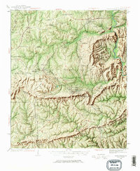
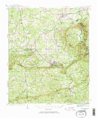
1934 Map of Warm Springs
USGS Topo · Published 1967About this map
Warm Springs Foundation and the adjacent US Fish Hatchery anchor this 1930s landscape, reflecting the region's prominence as a center for recovery and conservation. The terrain is defined by the prominent ridges of Pine Mountain and Oak Mountain, which separate the rail-linked industrial hubs like Manchester from smaller agricultural settlements such as Raleigh and Shiloh. The transportation network is remarkably dense, showing the intersection of the Central of Georgia and the Southern and Atlanta Birmingham and Coast railroads. A series of community crossroads, including McLendon Crossroads and Bulloch Crossroads, illustrate the rural social structure of the era, where local churches like Cane Creek Ch and Antioch Ch served as primary landmarks for Meriwether, Harris, and Talbot counties.
Find a feature on this map
107 named features on this map. Tap any name to fly to it.
Don’t see what you’re looking for? This feature index may not catch every label — zoom into the map to look around manually.
Map Details
Editions of this 1934 Warm Springs Map
7 editions found
Other maps of this area

1907 · Talbotton
USGS Topo · 1:125,000

1934 · Warm Springs
USGS Topo · 1:62,500

1935 · Thomaston
USGS Topo · 1:48,000

1936 · Warm Springs
USGS Topo · 1:62,500

1939 · Thomaston
USGS Topo · 1:62,500

1950 · Talbotton
USGS Topo · 1:24,000

1950 · Waverly Hall
USGS Topo · 1:24,000

1950 · Cataula
USGS Topo · 1:24,000

1950 · Talbotton
USGS Topo · 1:62,500

1950 · Ellerslie
USGS Topo · 1:62,500