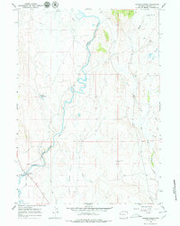
1966 Map of Warren Bridge
USGS Topo · Published 1980About this map
The Green River meanders through this portion of Sublette County, defining a landscape shaped by irrigation and ranching. The presence of numerous water-diversion features such as Canyon Ditch, Bickel Ditch, and Horsefly Ditch illustrates the vital role of water management in the high-elevation basin. These channels weave across the terrain near Forty Rod Flat, supporting the local agriculture that sustained the region's sparse population.
Find a feature on this map
19 named features on this map. Tap any name to fly to it.
Don’t see what you’re looking for? This feature index may not catch every label — zoom into the map to look around manually.
Map Details
Editions of this 1966 Warren Bridge Map
3 editions found
Other maps of this area

1907 · Gros Ventre
USGS Topo · 1:125,000

1909 · Fremont Peak
USGS Topo · 1:125,000

1910 · Gros Ventre
USGS Topo · 1:125,000

1939 · Big Piney
USGS Topo · 1:125,000

1942 · Big Piney
USGS Topo · 1:125,000

1955 · Driggs
USGS Topo · 1:250,000

1955 · Preston
USGS Topo · 1:250,000

1955 · Thermopolis
USGS Topo · 1:250,000

1955 · Lander
USGS Topo · 1:250,000

1958 · Driggs
USGS Topo · 1:250,000