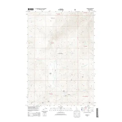
2013 Map of Warren
USGS Topo · Published 2013About this map
Warren serves as the central hub of this remote high-country landscape, situated within the Payette National Forest. This 2013 survey documents the infrastructure of a historic Idaho mining district, featuring the Warren USFS Airport and the Warren Forest Service Facility. The terrain is characterized by steep drainages and named gulches that tell a story of local prospecting, including Arlise Gulch, Halls Gulch, and Willey Gulch. Travel through the region is anchored by the Warren Wagon Rd, which follows the course of Warren Creek as it winds past Warren Meadow. To the north, the plateau of Republican Flats overlooks a complex network of tributaries such as Houston Creek and Richardson Creek. This map is a valuable resource for understanding the modern footprint of a legendary gold-rush town, capturing its administrative role and the persistent naming of the surrounding wilderness.
Find a feature on this map
45 named features on this map. Tap any name to fly to it.
Don’t see what you’re looking for? This feature index may not catch every label — zoom into the map to look around manually.
Map Details
Editions of this 2013 Warren Map
This is the sole edition of this map. No revisions or reprints were ever made.
Other maps of this area

1956 · Burgdorf
USGS Topo · 1:62,500

1956 · Warren
USGS Topo · 1:62,500

1956 · Elk City
USGS Topo · 1:250,000

1960 · Elk City
USGS Topo · 1:250,000

1969 · Loon Lake
USGS Topo · 1:24,000

1969 · Pony Meadows
USGS Topo · 1:24,000

1969 · Pilot Peak
USGS Topo · 1:24,000

1981 · Warren
USGS Topo · 1:100,000
1989 · Mackay Bar
USGS Topo · 1:24,000
1989 · Johnson Butte
USGS Topo · 1:24,000