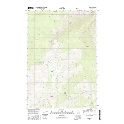
2017 Map of Warren
USGS Topo · Published 2017About this map
Warren is the central settlement in this mountainous region of the Payette National Forest, situated where Warren Creek meets Steamboat Creek. The landscape is defined by its deep drainages and named gulches, including Halls Gulch, Willey Gulch, and Artise Gulch, which suggest the historic mineral extraction history of the area. Transportation is concentrated along the Warren Wagon Road and the National Forest Development Road 340, providing access to the Warren /USFS Airport.
Find a feature on this map
51 named features on this map. Tap any name to fly to it.
Don’t see what you’re looking for? This feature index may not catch every label — zoom into the map to look around manually.
Map Details
Editions of this 2017 Warren Map
This is the sole edition of this map. No revisions or reprints were ever made.
Other maps of this area

1956 · Burgdorf
USGS Topo · 1:62,500

1956 · Warren
USGS Topo · 1:62,500

1956 · Elk City
USGS Topo · 1:250,000

1960 · Elk City
USGS Topo · 1:250,000

1969 · Loon Lake
USGS Topo · 1:24,000

1969 · Pony Meadows
USGS Topo · 1:24,000

1969 · Pilot Peak
USGS Topo · 1:24,000

1981 · Warren
USGS Topo · 1:100,000
1989 · Mackay Bar
USGS Topo · 1:24,000
1989 · Johnson Butte
USGS Topo · 1:24,000