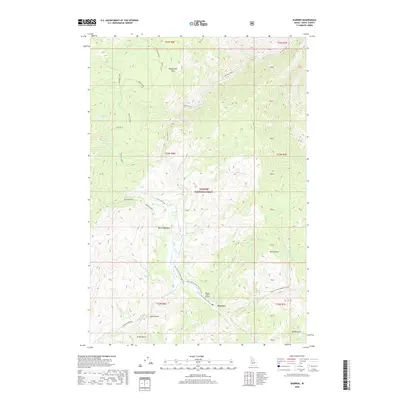
2020 Map of Warren
USGS Topo · Published 2020About this map
The mountain settlement of Warren occupies a narrow valley in the high country of the Payette National Forest, where historical gold mining activity is evidenced by the numerous named gulches and creeks. Transport in this isolated terrain is anchored by the Warren Wagon Rd and the Warren /USFS Airport, reflecting the infrastructure required to service this remote pocket of Idaho County. The landscape is characterized by high-elevation features such as Cottontail Point and Cooks Lake, with significant meadowlands including Floyd Meadows and Warren Meadow providing breaks in the dense forest cover. The drainage pattern is complex, with several watercourses like Warren Creek and Slaughter Cr defining the local topography. This map captures the modern footprint of a legendary Idaho mining district, documenting the relationship between the central townsite and its surrounding landforms like Republican Flats and Halls Gulch.
Find a feature on this map
53 named features on this map. Tap any name to fly to it.
Don’t see what you’re looking for? This feature index may not catch every label — zoom into the map to look around manually.
Map Details
Editions of this 2020 Warren Map
This is the sole edition of this map. No revisions or reprints were ever made.
Other maps of this area

1956 · Burgdorf
USGS Topo · 1:62,500

1956 · Warren
USGS Topo · 1:62,500

1956 · Elk City
USGS Topo · 1:250,000

1960 · Elk City
USGS Topo · 1:250,000

1969 · Loon Lake
USGS Topo · 1:24,000

1969 · Pony Meadows
USGS Topo · 1:24,000

1969 · Pilot Peak
USGS Topo · 1:24,000

1981 · Warren
USGS Topo · 1:100,000
1989 · Mackay Bar
USGS Topo · 1:24,000
1989 · Johnson Butte
USGS Topo · 1:24,000