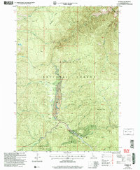
2004 Map of Warren
USGS Topo · Published 2007About this map
The settlement of Warren and its surrounding gold-mining legacy define this mountainous region within the Payette National Forest. This 2004 revision, based on 1980s topography and late-1990s imagery, documents a landscape heavily modified by historical and modern resource extraction. Extensive Tailings and multiple Mine sites, including the Rescue Mine and an Open Pit Mine, are concentrated along the north-south axis of Warren Creek. The presence of Republican Flats and Warren Meadow provide rare level ground in the high-elevation terrain, where an Airport and a Gaging Station support the local infrastructure. Hydrological features like Cooks Lake and the drainage of Richardson Creek carve through the forest, while a local Cem near the townsite offers a point of interest for genealogists tracing the families of this central Idaho mining district.
Find a feature on this map
33 named features on this map. Tap any name to fly to it.
Don’t see what you’re looking for? This feature index may not catch every label — zoom into the map to look around manually.
Map Details
Editions of this 2004 Warren Map
This is the sole edition of this map. No revisions or reprints were ever made.
Other maps of this area

1956 · Burgdorf
USGS Topo · 1:62,500

1956 · Warren
USGS Topo · 1:62,500

1956 · Elk City
USGS Topo · 1:250,000

1960 · Elk City
USGS Topo · 1:250,000

1969 · Loon Lake
USGS Topo · 1:24,000

1969 · Pony Meadows
USGS Topo · 1:24,000

1969 · Pilot Peak
USGS Topo · 1:24,000

1981 · Warren
USGS Topo · 1:100,000
1989 · Mackay Bar
USGS Topo · 1:24,000
1989 · Johnson Butte
USGS Topo · 1:24,000