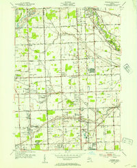
1952 Map of Warren
USGS Topo · Published 1953About this map
The Oakland Co Macomb Co line divides a landscape transitioning from rural farmland to post-war suburban development in this early 1950s study. The Clinton River and its numerous tributaries, including Plum Brook and Big Beaver Creek, dictate the drainage of the region, which is heavily interspersed with small airfields and recreational facilities. Notable landing strips like Wings Airport and Big Beaver Airport serve the growing aviation needs of the era, while the Sunnybrook Country Club and Dodge Bros State Park No 4 reflect the expanding leisure culture of the Detroit periphery. Local education and genealogy are anchored by landmarks like the Warren Cem and numerous district schools such as Colerain Sch and the Berz Sch (Abandoned), the latter marking the shifting community footprint as larger townships like Warren and Royal Oak begin to densify.
Find a feature on this map
68 named features on this map. Tap any name to fly to it.
Don’t see what you’re looking for? This feature index may not catch every label — zoom into the map to look around manually.
Map Details
Editions of this 1952 Warren Map
2 editions found
Other maps of this area

1905 · Detroit
USGS Topo · 1:62,500

1905 · Grosse Pointe
USGS Topo · 1:62,500

1908 · Rochester
USGS Topo · 1:62,500

1912 · Mt Clemens
USGS Topo · 1:62,500

1918 · Detroit
USGS Topo · 1:62,500

1918 · Grosse Pointe
USGS Topo · 1:62,500

1924 · Detroit
USGS Topo · 1:62,500

1929 · Mt Clemens
USGS Topo · 1:62,500

1934 · Detroit
USGS Topo · 1:62,500

1936 · Warren
USGS Topo · 1:31,680