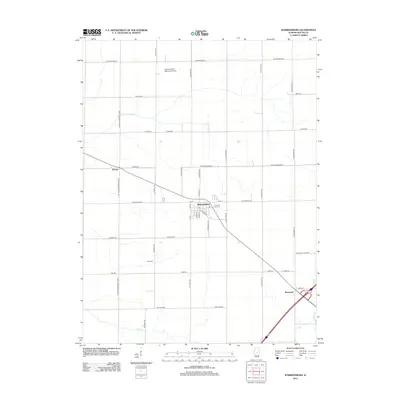
2012 Map of Warrensburg
USGS Topo · Published 2012About this map
Warrensburg stands as the central hub of this Central Illinois landscape, organized by the precise grid of the Public Land Survey System. The town center is detailed with streets such as E Main St and S Roosevelt St, anchored by the local Po. To the northwest, Colonel Smith Memorial Airport occupies a significant tract of land, reflecting the modern infrastructure of Macon County. The surrounding area remains largely agricultural, punctuated by small settlements like Heman and Bearsdale. Historical and genealogical interest is found at the Illini Cem south of Warrensburg, while the S Fork Lake Fork meanders through the northern section of the quadrangle. This layout demonstrates the enduring pattern of Midwestern farm-to-market settlements, where small rail-side communities like Bearsdale remain connected via a network of named country roads such as Schellabarger Rd and W Hampshire Rd.
Find a feature on this map
38 named features on this map. Tap any name to fly to it.
Don’t see what you’re looking for? This feature index may not catch every label — zoom into the map to look around manually.
Map Details
Editions of this 2012 Warrensburg Map
This is the sole edition of this map. No revisions or reprints were ever made.
Other maps of this area

1929 · Decatur
USGS Topo · 1:62,500

1933 · Decatur
USGS Topo · 1:62,500

1954 · Niantic
USGS Topo · 1:62,500

1957 · Kenney
USGS Topo · 1:62,500

1957 · Maroa
USGS Topo · 1:62,500

1958 · Peoria
USGS Topo · 1:250,000

1958 · Decatur
USGS Topo · 1:250,000

1961 · Peoria
USGS Topo · 1:250,000

1961 · Decatur
USGS Topo · 1:250,000

1963 · Peoria
USGS Topo · 1:250,000