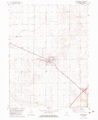
1982 Map of Warrensburg
USGS Topo · Published 1983About this map
Warrensburg and its surrounding townships define this central Illinois landscape in the early 1980s. The agricultural character of the region is punctuated by the diagonal path of the Illinois Central Gulf railroad, which links the settlements of Heman, Warrensburg, and Bearsdale. Local genealogy and social history are centered on the Illini Ch and its adjacent Illini Ch Cem, located south of the main village. The presence of the Warrensburg-Latham Sch indicates the shared educational infrastructure between neighboring communities. Water drainage follows the natural contours of Lake Fork and South Fork in the north, while Willow Branch meanders through the southern section near the small settlement of Willow. A Sew Disp Pond and a prominent Radio Tower reflect the local utility and communication developments of the era.
Find a feature on this map
19 named features on this map. Tap any name to fly to it.
Don’t see what you’re looking for? This feature index may not catch every label — zoom into the map to look around manually.
Map Details
Editions of this 1982 Warrensburg Map
This is the sole edition of this map. No revisions or reprints were ever made.
Other maps of this area

1929 · Decatur
USGS Topo · 1:62,500

1933 · Decatur
USGS Topo · 1:62,500

1954 · Niantic
USGS Topo · 1:62,500

1957 · Kenney
USGS Topo · 1:62,500

1957 · Maroa
USGS Topo · 1:62,500

1958 · Peoria
USGS Topo · 1:250,000

1958 · Decatur
USGS Topo · 1:250,000

1961 · Peoria
USGS Topo · 1:250,000

1961 · Decatur
USGS Topo · 1:250,000

1963 · Peoria
USGS Topo · 1:250,000