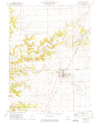
1972 Map of Washburn
USGS Topo · Published 1974About this map
Washburn and Wilbern anchor this central Illinois landscape in the early 1970s, where the rural character is defined by a dense network of country cemeteries and agricultural institutions. The map reveals a cluster of burial grounds including Buckingham Cem, Mt Vernon Cem, and Crow Meadow Cem, which serve as vital markers for genealogical research. Social and civic life is centered around the Grange Hall and Townhall, while the terrain is etched by drainage patterns like Pigeon Creek, Crow Creek, and Snag Creek.
Find a feature on this map
30 named features on this map. Tap any name to fly to it.
Don’t see what you’re looking for? This feature index may not catch every label — zoom into the map to look around manually.
Map Details
Editions of this 1972 Washburn Map
This is the sole edition of this map. No revisions or reprints were ever made.
Other maps of this area

1893 · Lacon
USGS Topo · 1:62,500

1893 · Metamora
USGS Topo · 1:62,500

1933 · Lacon
USGS Topo · 1:62,500

1934 · Wenona
USGS Topo · 1:48,000

1937 · Metamora
USGS Topo · 1:62,500

1937 · Lacon
USGS Topo · 1:62,500

1939 · Wenona
USGS Topo · 1:62,500

1948 · Metamora
USGS Topo · 1:62,500

1955 · Minonk
USGS Topo · 1:62,500

1958 · Aurora
USGS Topo · 1:250,000