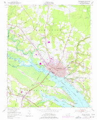
1951 Map of Washington
USGS Topo · Published 1977About this map
The Tar River and Pamlico River serve as the central geographic axis for this mid-century portrait of Beaufort County, where the transition from inland waterway to broad estuary defines the local economy and layout. In Washington, the street grid terminates at the busy riverfront near City Hall and The Castle, while just across the water, the settlement of Chocowinity marks a secondary hub linked by the Norfolk Southern railroad. Industrial and community landmarks like Warren Field and the Pamlico Race Track illustrate the post-war development of the area's flatlands.
Find a feature on this map
68 named features on this map. Tap any name to fly to it.
Don’t see what you’re looking for? This feature index may not catch every label — zoom into the map to look around manually.
Map Details
Editions of this 1951 Washington Map
3 editions found
Other maps of this area

1902 · Vanceboro
USGS Topo · 1:62,500

1903 · Chocowinity
USGS Topo · 1:62,500

1904 · Vanceboro
USGS Topo · 1:62,500

1905 · Chocowinity
USGS Topo · 1:62,500

1905 · Vanceboro
USGS Topo · 1:62,500

1943 · Plymouth
USGS Topo · 1:125,000

1951 · Bunyan
USGS Topo · 1:24,000

1951 · Hackney
USGS Topo · 1:24,000

1951 · Washington
USGS Topo · 1:24,000

1953 · Blounts Bay
USGS Topo · 1:24,000