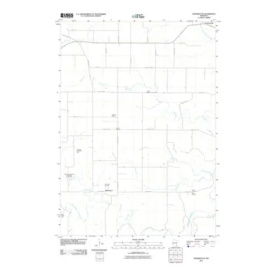
2010 Map of Washington
USGS Topo · Published 2010About this map
The small settlement of Washington serves as a central anchor in this section of Olmsted County, situated in a landscape defined by the winding paths of the North Branch Root River and Middle Branch Root River. This survey captures the rural character of the region, where a dense network of country roads like County Hwy-101 and County Hwy-4 connect scattered homesteads and significant community landmarks. The topography is shaped by numerous tributaries, including Bear Creek, Jordan Creek, and Carson Creek, many of which feature water management structures such as the Rudlong Structure Dam and Bear Creek Dam.
Find a feature on this map
28 named features on this map. Tap any name to fly to it.
Don’t see what you’re looking for? This feature index may not catch every label — zoom into the map to look around manually.
Map Details
Editions of this 2010 Washington Map
This is the sole edition of this map. No revisions or reprints were ever made.
Other maps of this area

1954 · Chatfield
USGS Topo · 1:62,500

1954 · Mason City
USGS Topo · 1:250,000

1955 · Stewartville
USGS Topo · 1:62,500

1957 · Mason City
USGS Topo · 1:250,000

1958 · Mason City
USGS Topo · 1:250,000

1965 · Wykoff
USGS Topo · 1:24,000

1965 · Spring Valley
USGS Topo · 1:24,000

1965 · Fountain
USGS Topo · 1:24,000
1974 · Marion
USGS Topo · 1:24,000
1974 · Chatfield
USGS Topo · 1:24,000