
1982 Map of Washington Island NE
USGS Topo · Published 1983About this map
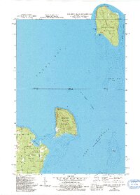
St Martin Island and Rock Island sit at the aquatic crossroads between Green Bay and Lake Michigan, separated by the deep waters of Rock Island Passage. The northern portion of the map is dominated by the small settlement of Fairbanks on St Martin Island, where a lone Cem and a Light mark the edge of the St Martin Island Passage. This 1982 revision captures the landscape just as the Michigan-Wisconsin state line cuts across the open water north of Rock Island State Park. On the northern tip of Washington Island, the community at Jackson Harbor is detailed with its localized road network including Indian Point Road and Townline Rd. The presence of several Gravel Pits and the Jackson Harbor Dunes Park suggests a balance of early industrial extraction and the preservation of the unique shoreline dunes.
Find a feature on this map
25 named features on this map. Tap any name to fly to it.
Don’t see what you’re looking for? This feature index may not catch every label — zoom into the map to look around manually.
Map Details
Editions of this 1982 Washington Island NE Map
2 editions found
Other maps of this area

1932 · Burnt Bluff SW
USGS Topo · 1:31,680

1954 · Escanaba
USGS Topo · 1:250,000

1957 · Escanaba
USGS Topo · 1:250,000

1958 · Escanaba
USGS Topo · 1:250,000

1958 · Peninsula Point
USGS Topo · 1:62,500

1958 · Fairport
USGS Topo · 1:62,500

1960 · Washington Island
USGS Topo · 1:62,500

1982 · Washington Island SE
USGS Topo · 1:24,000

1982 · Washington Island NW
USGS Topo · 1:24,000
1982 · Washington Island SW
USGS Topo · 1:24,000