
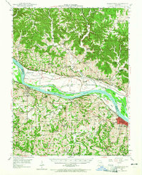
1948 Map of Washington
USGS Topo · Published 1962About this map
Washington and New Haven anchor this section of the river valley, where the Missouri River cuts a wide path through the borderlands of Warren and Franklin Counties. The landscape is defined by the heavy rail presence of the Missouri Pacific on the south bank and the Missouri Kansas Texas to the north, servicing riverfront settlements like Treloar, Peers, and Dundee. This survey provides a look at the rural social infrastructure of the mid-20th century, documenting dozens of localized schoolhouses such as Gerding Sch, Bierbaum Sch, and Ziegenmeyers Sch. North of the river, Marthasville sits near the Daniel Boone Monument, while the fertile La Charrette Bottom stretches across the floodplain. The map captures the area just as aerial topography was beginning to replace older manual methods, revealing the intricate drainage of Boeuf Creek and the many islands, like Miller Island and Watkins Island, that shifted with the river's flow.
Find a feature on this map
84 named features on this map. Tap any name to fly to it.
Don’t see what you’re looking for? This feature index may not catch every label — zoom into the map to look around manually.
Map Details
Editions of this 1948 Washington Map
2 editions found
Other maps of this area

1890 · Hermann
USGS Topo · 1:125,000

1901 · De Soto
USGS Topo · 1:125,000

1903 · O'Fallon
USGS Topo · 1:125,000

1903 · Sullivan
USGS Topo · 1:125,000

1935 · Gerald
USGS Topo · 1:48,000

1936 · Hermann
USGS Topo · 1:48,000

1941 · Gerald
USGS Topo · 1:62,500

1941 · Troy
USGS Topo · 1:62,500

1942 · Hermann
USGS Topo · 1:62,500

1942 · New Florence
USGS Topo · 1:62,500