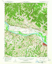
1948 Map of Washington
USGS Topo · Published 1965About this map
The Missouri River carves a deep valley through the heart of this Franklin and Warren County landscape, separating the high bluffs of Dundee Knob from the fertile alluvial soils of La Charrette Bottom and Boeuf Island. In the years following World War II, this region maintained a dense network of rural infrastructure, with numerous one-room schoolhouses like Dryer Sch, Cedar Grove Sch, and Gerding Sch serving the surrounding agricultural communities. The river acts as a corridor for the Kansas Texas Missouri and Pacific RR, which connects riverside towns like New Haven and Washington. On the northern banks near Marthasville, the Daniel Boone Monument stands as a local landmark. The map detail reflects a transition from traditional upland farming and ridge-top settlements like Concord Hill and Holstein to the industrial and commercial activity concentrated along the rail lines and water crossings of the valley floor.
Find a feature on this map
70 named features on this map. Tap any name to fly to it.
Don’t see what you’re looking for? This feature index may not catch every label — zoom into the map to look around manually.
Map Details
Editions of this 1948 Washington Map
2 editions found

Other maps of this area

1890 · Hermann
USGS Topo · 1:125,000

1901 · De Soto
USGS Topo · 1:125,000

1903 · O'Fallon
USGS Topo · 1:125,000

1903 · Sullivan
USGS Topo · 1:125,000

1935 · Gerald
USGS Topo · 1:48,000

1936 · Hermann
USGS Topo · 1:48,000

1941 · Gerald
USGS Topo · 1:62,500

1941 · Troy
USGS Topo · 1:62,500

1942 · Hermann
USGS Topo · 1:62,500

1942 · New Florence
USGS Topo · 1:62,500