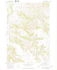
1954 Map of Wasta NE
USGS Topo · Published 1979About this map
The Cheyenne River winds along the northwestern corner of this territory, marking the boundary where Pennington Co meets Meade Co. This Missouri River Basin development survey reveals an arid landscape defined by deep draws and high buttes, centered on the broad elevations of Sunnyside and the plateau of Cow Flat. A network of ephemeral waterways, including Elk Creek, Cow Creek, and Calf Creek, carves through the terrain, illustrating the complex drainage patterns of this South Dakota ranching country. Sparse human infrastructure is focused around the Sunnyside Sch and localized Gravel Pit operations. The presence of Cedar Butte and Hay Draw in the south underscores the geographical isolation of the area during the mid-twentieth century, as mapped by the Department of the Interior.
Find a feature on this map
12 named features on this map. Tap any name to fly to it.
Don’t see what you’re looking for? This feature index may not catch every label — zoom into the map to look around manually.
Map Details
Editions of this 1954 Wasta NE Map
2 editions found
Other maps of this area

1953 · Rapid City
USGS Topo · 1:250,000

1954 · Dalzell SE
USGS Topo · 1:24,000

1954 · Wasta NE
USGS Topo · 1:24,000

1954 · Wasta SE
USGS Topo · 1:24,000

1954 · Dalzell
USGS Topo · 1:24,000

1954 · Wasta
USGS Topo · 1:24,000

1954 · Wasta NW
USGS Topo · 1:24,000

1955 · Creighton
USGS Topo · 1:24,000

1957 · Rapid City
USGS Topo · 1:250,000
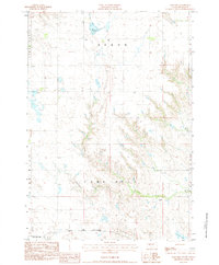
1983 · Lake Hill
USGS Topo · 1:24,000