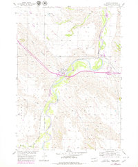
1954 Map of Wasta
USGS Topo · Published 1979About this map
The Cheyenne River winds through the heart of this Pennington County landscape, defining the topography of the western plains. The small settlement of Wasta serves as a central hub, situated where the Chicago and North Western railroad crosses the river valley. This transit corridor is further emphasized by the inclusion of modern highway infrastructure, including a designated Rest Area, which marks the evolution of travel through the region from rail to interstate road systems.
Find a feature on this map
19 named features on this map. Tap any name to fly to it.
Don’t see what you’re looking for? This feature index may not catch every label — zoom into the map to look around manually.
Map Details
Editions of this 1954 Wasta Map
2 editions found
Other maps of this area

1953 · Rapid City
USGS Topo · 1:250,000

1954 · Wasta NE
USGS Topo · 1:24,000

1954 · Wasta SE
USGS Topo · 1:24,000

1954 · Wasta
USGS Topo · 1:24,000

1954 · Owanka
USGS Topo · 1:24,000

1954 · Wasta NW
USGS Topo · 1:24,000

1954 · Brennan Flat
USGS Topo · 1:24,000

1954 · Quinn Table
USGS Topo · 1:24,000

1955 · Hot Springs
USGS Topo · 1:250,000

1957 · Rapid City
USGS Topo · 1:250,000