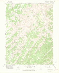
1964 Map of Water Canyon
USGS Topo · Published 1968About this map
The high desert drainages of Rio Blanco County are defined by a network of seasonal draws and early energy development in the mid-1960s. Douglas Creek serves as a primary north-south artery, flanked by the Douglas Pass Road and a notable industrial infrastructure including a Pipeline, several Gas Wells, and a Pumping Sta. The landscape is etched with local history through named livestock and transport routes like Big Horse Trail and the Dragon Rangely Road. Water management in this arid terrain is evidenced by several small impoundments such as Johnson Draw Reservoir and West Fourmile Reservoir, while numerous Drill Holes scattered across the draws of Water Canyon and Little Fourmile Draw signal the era's intensifying mineral exploration. A network of Jeep Trails provides the only access into the deeply dissected terrain of the Little Vandamore Draw.
Find a feature on this map
24 named features on this map. Tap any name to fly to it.
Don’t see what you’re looking for? This feature index may not catch every label — zoom into the map to look around manually.
Map Details
Editions of this 1964 Water Canyon Map
3 editions found
Other maps of this area

1907 · Rangely
USGS Topo · 1:125,000

1910 · Rangely
USGS Topo · 1:125,000

1954 · Vernal
USGS Topo · 1:250,000

1956 · Grand Junction
USGS Topo · 1:250,000

1958 · Vernal
USGS Topo · 1:250,000

1959 · Grand Junction
USGS Topo · 1:250,000

1960 · Vernal
USGS Topo · 1:250,000

1960 · Grand Junction
USGS Topo · 1:250,000

1962 · Grand Junction
USGS Topo · 1:250,000
1962 · Rangely
USGS Topo · 1:24,000