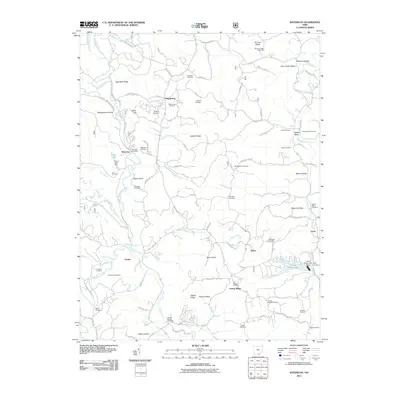
2011 Map of Waterloo
USGS Topo · Published 2011About this map
Symmes Creek and its many tributaries, including Johns Creek and Buck Creek, carve a complex network of ridges and hollows across this Lawrence County landscape. The settlement at Waterloo serves as a central point, home to the Waterloo Post Office and Waterloo Cemetery. Smaller communities and named locales such as Arabia, Yarico, and Flag Spring are connected by a web of narrow roads like Jenkins Rd and Arabia-Greasy Ridge Rd, reflecting the persistent rural character of southern Ohio.
Find a feature on this map
102 named features on this map. Tap any name to fly to it.
Don’t see what you’re looking for? This feature index may not catch every label — zoom into the map to look around manually.
Map Details
Editions of this 2011 Waterloo Map
This is the sole edition of this map. No revisions or reprints were ever made.
Other maps of this area

1898 · Ironton
USGS Topo · 1:62,500

1900 · Ironton
USGS Topo · 1:62,500

1906 · Bidwell
USGS Topo · 1:62,500

1906 · Athalia
USGS Topo · 1:62,500

1908 · Bidwell
USGS Topo · 1:62,500

1908 · Athalia
USGS Topo · 1:62,500

1912 · Oak Hill
USGS Topo · 1:62,500

1957 · Huntington
USGS Topo · 1:250,000
1958 · Athalia
USGS Topo · 1:24,000

1960 · Huntington
USGS Topo · 1:250,000