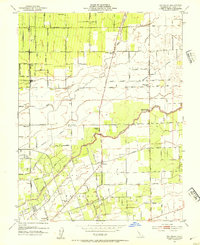
1953 Map of Waterloo
USGS Topo · Published 1954About this map
The Waterloo area and the southern reaches of the San Joaquin Valley floor are defined here by a dense grid of irrigation and transport infrastructure. The landscape of the Campo De Los Franceses land grant is crisscrossed by several vital waterways, including the Mokelumne River, the Calaveras River, and the Bear Creek. The engineering of the Central Valley is evident in the presence of the Mokelumne Aqueduct and the extensive levee systems protecting the fertile lowlands.
Find a feature on this map
41 named features on this map. Tap any name to fly to it.
Don’t see what you’re looking for? This feature index may not catch every label — zoom into the map to look around manually.
Map Details
Editions of this 1953 Waterloo Map
2 editions found
Other maps of this area

1894 · Lodi
USGS Topo · 1:125,000

1908 · Waterloo
USGS Topo · 1:31,680

1908 · Linden
USGS Topo · 1:31,680

1908 · Lockeford
USGS Topo · 1:31,680

1909 · Clements
USGS Topo · 1:31,680

1910 · Castle
USGS Topo · 1:31,680

1910 · Woodbridge
USGS Topo · 1:31,680

1913 · Stockton
USGS Topo · 1:31,680

1914 · Burnham
USGS Topo · 1:31,680

1915 · Peters
USGS Topo · 1:31,680