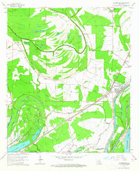
1963 Map of Waterproof
USGS Topo · Published 1964About this map
The town of Waterproof and its surrounding riverine landscape are defined by the complex hydrology of the Mississippi River and the Tensas River. In the early 1960s, this region was a patchwork of agricultural land and cypress-rich wetlands, evidenced by the numerous oxbows like Lake St John and Fletchers Lake. The presence of established estates such as Arcola Plantation and Winona Plantation reflects the historical land-use patterns of the Louisiana Delta. Transportation and industry are anchored by the Missouri Pacific railroad line and active gas and oil wells. Local community life is documented through scattered landmarks including Richland Church, Shiloh Church, and the Helena Cemetery, which provide essential touchstones for genealogical research in both Tensas Parish and Concordia Parish.
Find a feature on this map
45 named features on this map. Tap any name to fly to it.
Don’t see what you’re looking for? This feature index may not catch every label — zoom into the map to look around manually.
Map Details
Editions of this 1963 Waterproof Map
2 editions found
Other maps of this area

1909 · Delta Bridge
USGS Topo · 1:24,000

1921 · Natchez
USGS Topo · 1:48,000

1922 · Natchez
USGS Topo · 1:62,500

1939 · Red Gum
USGS Topo · 1:62,500

1939 · Natchez
USGS Topo · 1:62,500

1939 · Locust Ridge
USGS Topo · 1:62,500

1941 · Sicily Island
USGS Topo · 1:62,500

1953 · Natchez
USGS Topo · 1:250,000

1956 · Natchez
USGS Topo · 1:250,000

1957 · Sicily Island
USGS Topo · 1:62,500