1953 Map of Watertown
USGS Topo · Published 1974About this map
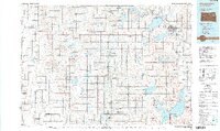
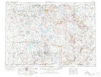
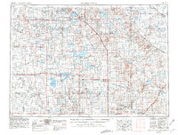
Glacial geology and the sprawling plateau of the Coteau des Prairies dominate this mid-century view of eastern South Dakota and western Minnesota. The landscape is defined by its massive water bodies, including Lake Poinsett, Lake Thompson, and Lake Kampeska, which surround the regional hub of Watertown. This area serves as a critical agricultural and transportation corridor, with the Big Sioux River winding through the terrain. The map captures the significant presence of the Sisseton Indian Reservation and Flandreau Indian Reservation, alongside established rail networks like the Chicago Milwaukee St Paul and Pacific. From the county seat of Brookings to smaller rail stops like De Smet and Arlington, the pattern of 1950s prairie settlement and the vast lake systems are preserved here in meticulous detail.
Find a feature on this map
158 named features on this map. Tap any name to fly to it.
Don’t see what you’re looking for? This feature index may not catch every label — zoom into the map to look around manually.
Map Details
Editions of this 1953 Watertown Map
3 editions found

Historical Maps of Watertown Through Time
3 maps found