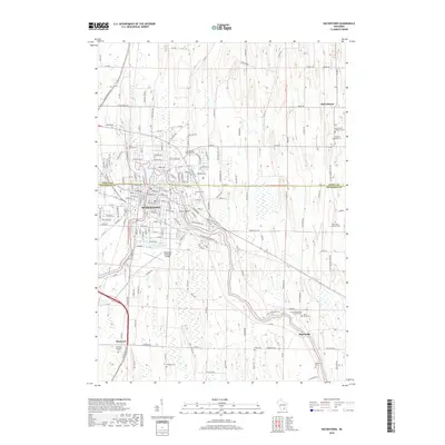
2018 Map of Watertown
USGS Topo · Published 2018About this map
The city of Watertown straddles the border of Dodge and Jefferson counties, centered on a major bend of the Rock River. This detailed survey highlights the urban core and its surrounding agricultural landscape, characterized by numerous rural burial grounds and historic churches. Notable sites within the city include Tivoli Island, Lake Victoria, and Heiden Pond, reflecting the community's relationship with its waterways. To the south, the Watertown Municipal Airport sits near the Watertown Byp, marking modern infrastructure developments.
Find a feature on this map
176 named features on this map. Tap any name to fly to it.
Don’t see what you’re looking for? This feature index may not catch every label — zoom into the map to look around manually.
Map Details
Editions of this 2018 Watertown Map
This is the sole edition of this map. No revisions or reprints were ever made.
Other maps of this area

1891 · Waterloo
USGS Topo · 1:62,500

1892 · Watertown
USGS Topo · 1:62,500

1894 · Waterloo
USGS Topo · 1:62,500

1894 · Watertown
USGS Topo · 1:62,500

1910 · Waterloo
USGS Topo · 1:62,500

1955 · Beaver Dam
USGS Topo · 1:62,500

1955 · Horicon
USGS Topo · 1:62,500

1957 · Madison
USGS Topo · 1:250,000
1959 · Richwood
USGS Topo · 1:24,000
1959 · Helenville
USGS Topo · 1:24,000