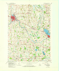
1959 Map of Watertown
USGS Topo · Published 1980About this map
The Rock River winds through this mid-century landscape, anchoring the city of Watertown and its surrounding agricultural townships. In the 1950s, the area served as a vital junction for the Chicago Milwaukee St Paul and Pacific and the Chicago and North Western railroads, which facilitated the movement of goods through small hubs like Ixonia and Ashippun. This survey captures a dense network of country schools and churches, including Northwestern College and the St Paul Sch, reflecting the community's deep-rooted educational and religious foundations.
Find a feature on this map
103 named features on this map. Tap any name to fly to it.
Don’t see what you’re looking for? This feature index may not catch every label — zoom into the map to look around manually.
Map Details
Editions of this 1959 Watertown Map
3 editions found
Other maps of this area

1891 · Waterloo
USGS Topo · 1:62,500

1891 · Koshkonong
USGS Topo · 1:62,500

1892 · Watertown
USGS Topo · 1:62,500

1892 · Oconomowoc
USGS Topo · 1:62,500

1892 · Whitewater
USGS Topo · 1:62,500

1892 · Eagle
USGS Topo · 1:62,500

1893 · Whitewater
USGS Topo · 1:62,500

1894 · Waterloo
USGS Topo · 1:62,500

1894 · Watertown
USGS Topo · 1:62,500

1894 · Eagle
USGS Topo · 1:62,500