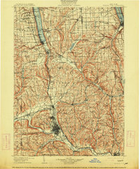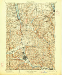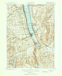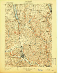
1905 Map of Watkins Glen
USGS Topo · Published 1919About this map
Seneca Lake and Cayuga Lake dominate the northern terrain of this 1905 survey, providing a clear view of the Finger Lakes region during a period of heavy rail expansion. The landscape is defined by the deep gorges and falls of the southern lake shores, most notably at the iconic Watkins Glen and Buttermilk Falls. A dense concentration of infrastructure is visible at Elmira and Horseheads, where the Erie RR and Northern Central RR converged to support the industrial activity of the Chemung River valley. Higher elevations like Connecticut Hill and Key Hill separate the lake basins from the southern river systems. This map captures several small hamlets and landings along the shores, including Glenora and Peach Orchard, which served as vital points for local transport and commerce before the prominence of the automobile.
Find a feature on this map
154 named features on this map. Tap any name to fly to it.
Don’t see what you’re looking for? This feature index may not catch every label — zoom into the map to look around manually.
Map Details
Editions of this 1905 Watkins Glen Map
4 editions found