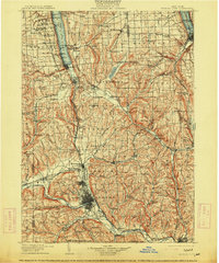
1905 Map of Watkins Glen
USGS Topo · Published 1914About this map
Seneca Lake and Cayuga Lake anchor this turn-of-the-century topographic landscape, where the Finger Lakes region transitions from steep glaciated valleys to the industrial hubs of the Southern Tier. The map documents a dense network of early transportation, featuring the Steerboat Route on the deep waters of Seneca Lake and several competing rail lines, including the Lehigh Valley RR and the Northern Central RR, which were critical for the era's commerce.
Find a feature on this map
191 named features on this map. Tap any name to fly to it.
Don’t see what you’re looking for? This feature index may not catch every label — zoom into the map to look around manually.
Map Details
Editions of this 1905 Watkins Glen Map
4 editions found

Other maps of this area

1893 · Ithaca
USGS Topo · 1:62,500

1895 · Ithaca
USGS Topo · 1:62,500

1895 · Elmira
USGS Topo · 1:62,500

1898 · Moravia
USGS Topo · 1:62,500

1898 · Watkins Glen
USGS Topo · 1:62,500

1900 · Tioga
USGS Topo · 1:62,500

1900 · Dryden
USGS Topo · 1:62,500

1901 · Watkins
USGS Topo · 1:62,500

1902 · Waverly
USGS Topo · 1:62,500

1902 · Moravia
USGS Topo · 1:62,500