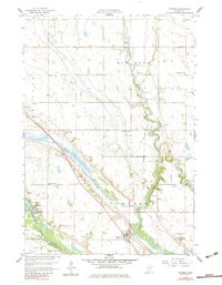
1958 Map of Watson
USGS Topo · Published 1983About this map
The Chippewa River meanders dramatically across this West Central Minnesota landscape, defining the rural character of Tunsberg and Kragero townships. The village of Watson serves as the local hub, situated where the Chicago Milwaukee St Paul and Pacific railroad cuts a straight line through the river valley. This era of the late 1950s captures a dense network of local education and faith, marked by numerous rural schoolhouses such as School No 288 and School No 277, alongside the Zion Ch and the Immanuel Sch. Near the confluence of the Lac qui Parle River, the map identifies significant commemorative and recreational sites including Camp Release and Lac qui Parle Mission Park, which preserve the complex historical narrative of the Minnesota River valley.
Find a feature on this map
28 named features on this map. Tap any name to fly to it.
Don’t see what you’re looking for? This feature index may not catch every label — zoom into the map to look around manually.
Map Details
Editions of this 1958 Watson Map
3 editions found
Other maps of this area

1953 · New Ulm
USGS Topo · 1:250,000

1953 · Saint Cloud
USGS Topo · 1:250,000

1957 · Saint Cloud
USGS Topo · 1:250,000

1957 · New Ulm
USGS Topo · 1:250,000

1958 · New Ulm
USGS Topo · 1:250,000

1958 · Saint Cloud
USGS Topo · 1:250,000

1958 · Milan
USGS Topo · 1:24,000

1958 · Big Bend City
USGS Topo · 1:24,000

1958 · Watson
USGS Topo · 1:24,000

1958 · Milan NW
USGS Topo · 1:24,000