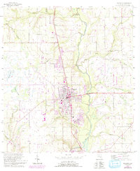
1955 Map of Wauchula
USGS Topo · Published 1993About this map
The Peace River carves a winding path through this central Florida landscape, anchoring a corridor of citrus groves and railroad development. Following the Seaboard Coast Line tracks, the map details the growth of Wauchula and the smaller settlements of Torrey, Coker, and Zolfo Springs. The area's agricultural and rural character is evidenced by the numerous named watercourses such as Payne Creek and Little Charlie Creek, which drain into the river system through wetlands like Reephook Swamp.
Find a feature on this map
30 named features on this map. Tap any name to fly to it.
Don’t see what you’re looking for? This feature index may not catch every label — zoom into the map to look around manually.
Map Details
Editions of this 1955 Wauchula Map
4 editions found
Other maps of this area

1955 · Ft. Green
USGS Topo · 1:24,000

1955 · Bowling Green
USGS Topo · 1:24,000

1955 · Wauchula
USGS Topo · 1:24,000

1955 · Baird
USGS Topo · 1:24,000

1956 · Ona
USGS Topo · 1:24,000

1956 · Bereah
USGS Topo · 1:24,000

1956 · Sweetwater
USGS Topo · 1:24,000

1956 · Zolfo Springs
USGS Topo · 1:24,000

1956 · Griffins Corner
USGS Topo · 1:24,000

1956 · Fort Pierce
USGS Topo · 1:250,000