
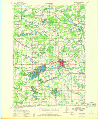
1957 Map of Waupaca
USGS Topo · Published 1959About this map
The Waupaca Chain O' Lakes district is meticulously detailed in this mid-century survey, showcasing the intricate network of water bodies and islands that define the Farmington and Dayton townships. Small settlements such as King and the rustic village of Rural sit adjacent to Rainbow Lake and McCrossen Lake, while larger communities like Waupaca serve as regional hubs for the surrounding dairy and agricultural lands. The landscape is dotted with a high density of rural schoolhouses, including Gards Corner Sch and Oakland Sch, indicating a well-established community infrastructure before the consolidation of rural districts.
Find a feature on this map
125 named features on this map. Tap any name to fly to it.
Don’t see what you’re looking for? This feature index may not catch every label — zoom into the map to look around manually.
Map Details
Editions of this 1957 Waupaca Map
2 editions found
Other maps of this area

1955 · Clintonville
USGS Topo · 1:48,000

1955 · Tigerton
USGS Topo · 1:48,000

1955 · Rosholt
USGS Topo · 1:48,000

1955 · Green Bay
USGS Topo · 1:250,000

1956 · Weyauwega
USGS Topo · 1:48,000

1957 · Amherst
USGS Topo · 1:48,000

1959 · Wautoma
USGS Topo · 1:48,000

1961 · Poy Sippi
USGS Topo · 1:62,500

1961 · Redgranite
USGS Topo · 1:62,500

1961 · Saxeville
USGS Topo · 1:24,000