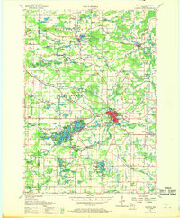
1957 Map of Waupaca
USGS Topo · Published 1969About this map
Glacial topography defines the landscape around Waupaca and Scandinavia, where dozens of kettle lakes and marshes are interspersed with a dense network of mid-century rural schoolhouses. In the town of Farmington, the chain of lakes including Rainbow Lake and McCrossen Lake supports early recreation sites like the Waupaca Boys Camp, while the surrounding countryside is dotted with genealogy-rich landmarks such as Peterson Mill Sch and Badger Ch.
Find a feature on this map
135 named features on this map. Tap any name to fly to it.
Don’t see what you’re looking for? This feature index may not catch every label — zoom into the map to look around manually.
Map Details
Editions of this 1957 Waupaca Map
2 editions found
Other maps of this area

1955 · Clintonville
USGS Topo · 1:48,000

1955 · Tigerton
USGS Topo · 1:48,000

1955 · Rosholt
USGS Topo · 1:48,000

1955 · Green Bay
USGS Topo · 1:250,000

1956 · Weyauwega
USGS Topo · 1:48,000

1957 · Amherst
USGS Topo · 1:48,000

1957 · Waupaca
USGS Topo · 1:48,000

1959 · Wautoma
USGS Topo · 1:48,000

1961 · Poy Sippi
USGS Topo · 1:62,500

1961 · Redgranite
USGS Topo · 1:62,500