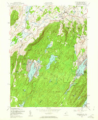
1954 Map of Wawayanda
USGS Topo · Published 1962About this map
Wawayanda Mountain and the Bearfort Mountain range dominate this landscape along the border of New York and New Jersey. The 1954 revision reveals a region defined by its high-elevation water bodies, including the central Wawayanda Lake and the developing residential clusters around Highland Lakes and Upper Greenwood Lake. The transition from the agricultural lowlands of Vernon Valley to the forested ridges is marked by old infrastructure like the Lehigh and Hudson River railroad and the Appalachian Trail.
Find a feature on this map
63 named features on this map. Tap any name to fly to it.
Don’t see what you’re looking for? This feature index may not catch every label — zoom into the map to look around manually.
Map Details
Editions of this 1954 Wawayanda Map
4 editions found
Other maps of this area

1888 · Franklin
USGS Topo · 1:62,500

1891 · Greenwood Lake
USGS Topo · 1:62,500

1893 · Greenwood Lake
USGS Topo · 1:62,500

1894 · Franklin
USGS Topo · 1:62,500

1897 · Franklin
USGS Topo · 1:62,500

1903 · Franklin Furnace
USGS Topo · 1:62,500

1903 · Greenwood Lake
USGS Topo · 1:62,500

1906 · Port Jervis
USGS Topo · 1:62,500

1906 · Goshen
USGS Topo · 1:62,500

1908 · Goshen
USGS Topo · 1:62,500