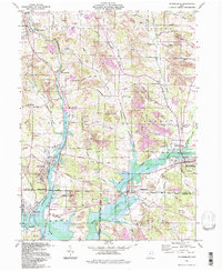
1994 Map of Waynesburg
USGS Topo · Published 1998About this map
Nimishillen Creek and Sandy Creek converge in this industrial and agricultural landscape where the borders of Stark, Carroll, and Tuscarawas counties meet. During the mid-1990s, the region's character was defined by extensive surface mining operations, with numerous Strip Mines appearing across the hillsides of Osnaburg and Pike townships. The local infrastructure supported both manufacturing and transport, evidenced by the Conrail line and the Magnolia Airport. Cultural and community centers are well-represented, from the Sandy Valley High Sch to several rural congregations like Centenary Chapel and Mt Zion Ch. This survey captures the transition between established towns like Waynesburg and Magnolia and the sprawling extractive industry that has reshaped the local topography. Genealogists will find value in the clear documentation of smaller burial grounds, including the Bowman Cem and Farber Cem.
Find a feature on this map
55 named features on this map. Tap any name to fly to it.
Don’t see what you’re looking for? This feature index may not catch every label — zoom into the map to look around manually.
Map Details
Editions of this 1994 Waynesburg Map
This is the sole edition of this map. No revisions or reprints were ever made.
Other maps of this area

1901 · Canton
USGS Topo · 1:62,500

1903 · Canton
USGS Topo · 1:62,500

1909 · Alliance
USGS Topo · 1:62,500

1910 · Carrollton
USGS Topo · 1:62,500

1912 · Dover
USGS Topo · 1:62,500

1912 · Carrollton
USGS Topo · 1:62,500

1944 · Dover
USGS Topo · 1:62,500

1951 · Canton
USGS Topo · 1:250,000

1951 · Bolivar
USGS Topo · 1:24,000

1953 · Canton
USGS Topo · 1:250,000