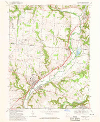
1968 Map of Waynesville
USGS Topo · Published 1970About this map
The Little Miami River corridor serves as the primary geographic axis for this 1968 survey, tracing a path through the intersection of Montgomery, Greene, and Warren Counties. The settlement of Waynesville anchors the southwest, with its street grid and the neighboring village of Corwin situated across the river. To the northeast, the Penn Central railroad tracks parallel the river valley, passing through small communities like Roxanna and Spring Valley. This era marks a significant preservation of the natural landscape, seen in the established boundaries of the Sugarcreek Reserve near Centerville and the Spring Valley Wildlife Area. Local history is deeply embedded in the rural landscape through sites like the Miami Cemetery and family-named roads such as Chenoweth Road and Satterthwaites Road. The terrain transitions from the upland plains of Washington township into the carved valleys of Caesar Creek and Shaffers Run.
Find a feature on this map
68 named features on this map. Tap any name to fly to it.
Don’t see what you’re looking for? This feature index may not catch every label — zoom into the map to look around manually.
Map Details
Editions of this 1968 Waynesville Map
3 editions found
Other maps of this area

1907 · Blanchester
USGS Topo · 1:62,500

1913 · Waynesville
USGS Topo · 1:62,500

1914 · Morrow
USGS Topo · 1:62,500

1915 · Waynesville
USGS Topo · 1:62,500

1916 · Morrow
USGS Topo · 1:62,500

1917 · Xenia
USGS Topo · 1:62,500

1947 · Columbus
USGS Topo · 1:250,000

1953 · Cincinnati
USGS Topo · 1:250,000

1955 · New Burlington
USGS Topo · 1:24,000
1955 · Lebanon
USGS Topo · 1:24,000