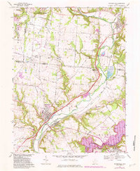
1968 Map of Waynesville
USGS Topo · Published 1982About this map
The Little Miami River corridor serves as the primary artery for this portion of southwest Ohio, where the village of Waynesville and the neighboring community of Corwin sit at a significant river crossing. By the late 1960s, this landscape reflected a mix of established agricultural settlements and the growing influence of regional conservation and recreation areas. Large tracts of land appear dedicated to nature, including the Sugarcreek Reserve and the Spring Valley Wildlife Area, while the nascent Caesar Creek State Park is visible to the southeast. The map reveals a dense network of local history, preserved in sites like the Miami Cemetery and Middle Run Ch. Transportation patterns are well-defined by the Conrail line running parallel to the river and a system of historic routes like Social Row Road and Ferry Road, indicating the movement of people and goods through these river valley townships.
Find a feature on this map
71 named features on this map. Tap any name to fly to it.
Don’t see what you’re looking for? This feature index may not catch every label — zoom into the map to look around manually.
Map Details
Editions of this 1968 Waynesville Map
3 editions found
Other maps of this area

1907 · Blanchester
USGS Topo · 1:62,500

1913 · Waynesville
USGS Topo · 1:62,500

1914 · Morrow
USGS Topo · 1:62,500

1915 · Waynesville
USGS Topo · 1:62,500

1916 · Morrow
USGS Topo · 1:62,500

1917 · Xenia
USGS Topo · 1:62,500

1947 · Columbus
USGS Topo · 1:250,000

1953 · Cincinnati
USGS Topo · 1:250,000

1955 · New Burlington
USGS Topo · 1:24,000
1955 · Lebanon
USGS Topo · 1:24,000