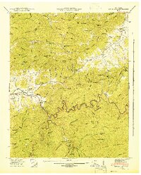
1942 Map of Wear Cove
USGS Topo · Published 1942About this map
Tuckaleechee and Townsend anchor the western edge of this 1941 Tennessee Valley Authority survey, which documents the complex settlement patterns along the northern boundary of the Great Smoky Mountains National Park. The landscape is defined by the steep transition from the Blount and Sevier county line down into the productive bottomlands of Little River. This map is particularly valuable for documenting rural community centers before mid-century changes, showing the locations of several family-named landmarks and local institutions like Headrick Chapel, Wearwood Sch, and Coker Hill Chapel.
Find a feature on this map
169 named features on this map. Tap any name to fly to it.
Don’t see what you’re looking for? This feature index may not catch every label — zoom into the map to look around manually.
Map Details
Editions of this 1942 Wear Cove Map
2 editions found
Other maps of this area

1886 · Knoxville
USGS Topo · 1:125,000

1892 · Knoxville
USGS Topo · 1:125,000

1894 · Knoxville
USGS Topo · 1:125,000

1895 · Knoxville
USGS Topo · 1:125,000

1901 · Knoxville
USGS Topo · 1:125,000

1935 · Knoxville
USGS Topo · 1:48,000

1935 · Walden Creek
USGS Topo · 1:24,000

1935 · Wildwood
USGS Topo · 1:24,000

1935 · Sevierville
USGS Topo · 1:48,000
1935 · Pigeon Forge
USGS Topo · 1:24,000