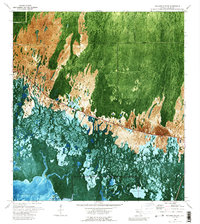
1972 Map of Weavers Station
USGS Topo · Published 1989About this map
Fakahatchee Bay and Ferguson Bay anchor the southern reaches of this 1970s orthophotomap, where the mangrove-heavy coastline meets the vast wetland interior of Everglades National Park. This specific survey period captures the area just as aerial photography was beginning to provide a new perspective on the complex hydrology of the Dana River and Barron River. The northern portion of the quadrangle is defined by a series of distinct ecological zones, including House Prairie, Four Stake Prairie, and the dense timber of the Fakahatchee Strand.
Find a feature on this map
14 named features on this map. Tap any name to fly to it.
Don’t see what you’re looking for? This feature index may not catch every label — zoom into the map to look around manually.
Map Details
Editions of this 1972 Weavers Station Map
3 editions found
Other maps of this area

1956 · Miami
USGS Topo · 1:250,000

1956 · West Palm Beach
USGS Topo · 1:250,000

1957 · West Palm Beach
USGS Topo · 1:250,000

1958 · West Palm Beach
USGS Topo · 1:250,000

1958 · Miami
USGS Topo · 1:250,000

1958 · Belle Meade SE
USGS Topo · 1:24,000

1959 · Deep Lake
USGS Topo · 1:24,000

1959 · Deep Lake SW
USGS Topo · 1:24,000

1972 · Weavers Station
USGS Topo · 1:24,000

1972 · Ochopee
USGS Topo · 1:24,000