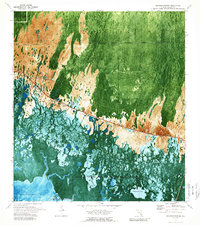
1972 Map of Weavers Station
USGS Topo · Published 1989About this map
The Tamiami Trail and its accompanying Tamiami Canal slice through the heart of the Florida Everglades in this 1970s orthophotomap, marking the primary human corridor through a landscape defined by water and grass. To the south, the map captures the transition into Everglades National Park, where the dense vegetation of the Fakahatchee Strand gives way to the open waters of Fakahatchee Bay and Ferguson Bay.
Find a feature on this map
20 named features on this map. Tap any name to fly to it.
Don’t see what you’re looking for? This feature index may not catch every label — zoom into the map to look around manually.
Map Details
Editions of this 1972 Weavers Station Map
3 editions found
Other maps of this area

1956 · Miami
USGS Topo · 1:250,000

1956 · West Palm Beach
USGS Topo · 1:250,000

1957 · West Palm Beach
USGS Topo · 1:250,000

1958 · West Palm Beach
USGS Topo · 1:250,000

1958 · Miami
USGS Topo · 1:250,000

1958 · Belle Meade SE
USGS Topo · 1:24,000

1959 · Deep Lake
USGS Topo · 1:24,000

1959 · Deep Lake SW
USGS Topo · 1:24,000

1972 · Weavers Station
USGS Topo · 1:24,000

1972 · Ochopee
USGS Topo · 1:24,000