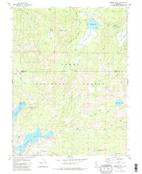
1981 Map of Webber Peak
USGS Topo · Published 1987About this map
The high Sierra Nevada divide within the Tahoe National Forest is defined here by a series of significant mountain lakes and the headwaters of major California rivers. Webber Lake sits in the north, feeding into the Little Truckee River, while the Middle Yuba River emerges to the west. This alpine landscape, mapped in the early 1980s, shows the path of the Pacific Crest National Scenic Trail as it traverses the ridges above Meadow Lake and Fordyce Lake. Historical mining activity is marked by the Anderson Mine and other unnamed mines near the southern shoreline of Meadow Lake. The map illustrates a complex drainage system where Lacey Creek and Perazzo Creek navigate through wide glacial meadows like Coppins Meadow and Perazzo Meadows.
Find a feature on this map
31 named features on this map. Tap any name to fly to it.
Don’t see what you’re looking for? This feature index may not catch every label — zoom into the map to look around manually.
Map Details
Editions of this 1981 Webber Peak Map
3 editions found
Other maps of this area

1890 · Sierraville
USGS Topo · 1:125,000

1891 · Downieville
USGS Topo · 1:125,000

1891 · Colfax
USGS Topo · 1:125,000

1891 · Truckee
USGS Topo · 1:125,000

1892 · Sierraville
USGS Topo · 1:125,000

1892 · Colfax
USGS Topo · 1:125,000

1893 · Truckee
USGS Topo · 1:125,000

1893 · Downieville
USGS Topo · 1:125,000

1894 · Colfax
USGS Topo · 1:125,000

1894 · Sierraville
USGS Topo · 1:125,000