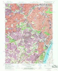
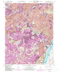
1954 Map of Webster Groves
USGS Topo · Published 1969About this map
Jefferson Barracks anchors the southern riverfront in this mid-century survey, a landscape where the urban density of St Louis meets suburban growth in Webster Groves and Brentwood. The map documents a corridor defined by significant institutional and religious presence, from Webster College and St Josephs Convent of Mercy to several theological centers like Kenrick Seminary and the St Louis Preparatory Seminary. The complex drainage of the River Des Peres Drainage Channel cuts through the territory, flanked by numerous large burial grounds including Resurrection Cemetery and Ss Peter and Paul Cemetery. The era's transportation network is captured in the transition from the rail lines of the Missouri Pacific and St Louis-San Francisco railroads to the developing interstate system, while established green spaces like the Missouri Botanical Garden and Tower Grove Park remain core landmarks.
Find a feature on this map
109 named features on this map. Tap any name to fly to it.
Don’t see what you’re looking for? This feature index may not catch every label — zoom into the map to look around manually.
Map Details
Editions of this 1954 Webster Groves Map
5 editions found
Other maps of this area

1888 · St. Louis
USGS Topo · 1:62,500

1910 · Waterloo
USGS Topo · 1:62,500

1912 · Kimmswick
USGS Topo · 1:62,500

1913 · Waterloo
USGS Topo · 1:62,500

1916 · Kimmswick
USGS Topo · 1:62,500

1933 · Creve Coeur
USGS Topo · 1:24,000

1933 · Granite City
USGS Topo · 1:24,000

1933 · Jefferson Barracks
USGS Topo · 1:24,000

1933 · Cahokia
USGS Topo · 1:24,000

1933 · Clayton
USGS Topo · 1:24,000