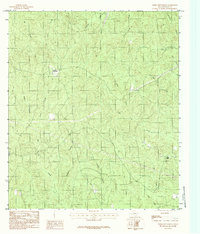
1984 Map of Weeks Settlement
USGS Topo · Published 1984About this map
Weeks Settlement stands as the central namesake of this Southeast Texas landscape, situated amidst a dense network of watercourses that define the local geography. The map reveals a timber and resource-based economy, evidenced by the presence of a Lookout Tower overlooking the forested terrain and a Gravel Pit near Belcher Creek. The drainage patterns are intricate, with major arteries like Big Cow Creek and Little Cow Creek joined by numerous named tributaries such as Crenshaw Branch and Jordan Branch. High points like Twin Hills and the Indian Hills provide relief in a region where local aviation is supported by a solitary Landing Strip. This 1980s-era documentation captures the area's rural character before further modernization, emphasizing the historical importance of small family or community settlements and the natural branch-and-creek systems that dictated land use in Newton County.
Find a feature on this map
25 named features on this map. Tap any name to fly to it.
Don’t see what you’re looking for? This feature index may not catch every label — zoom into the map to look around manually.
Map Details
Editions of this 1984 Weeks Settlement Map
This is the sole edition of this map. No revisions or reprints were ever made.
Other maps of this area

1944 · Wiergate
USGS Topo · 1:62,500

1948 · Wiergate
USGS Topo · 1:62,500

1952 · Lake Charles
USGS Topo · 1:250,000

1953 · Alexandria
USGS Topo · 1:250,000

1954 · Wiergate
USGS Topo · 1:24,000

1954 · Fairdale
USGS Topo · 1:24,000

1954 · Wiergate
USGS Topo · 1:62,500

1954 · Lake Charles
USGS Topo · 1:250,000

1955 · Alexandria
USGS Topo · 1:250,000

1955 · Roganville
USGS Topo · 1:62,500