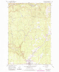
1966 Map of Weippe North
USGS Topo · Published 1984About this map
The logging and agricultural hub of Weippe serves as the focal point of this mid-1960s survey of Clearwater County. Situated on the expansive Weippe Prairie, the settlement is surrounded by a working landscape shaped by the timber industry, evidenced by numerous production sites such as Battles Mill, Johnsons Mill, and McCann Mill. The terrain is defined by a dense network of drainages, including the prominent Orofino Creek and Jim Ford Creek, which carve through the high plateau.
Find a feature on this map
27 named features on this map. Tap any name to fly to it.
Don’t see what you’re looking for? This feature index may not catch every label — zoom into the map to look around manually.
Map Details
Editions of this 1966 Weippe North Map
2 editions found
Other maps of this area

1923 · Washington Creek
USGS Topo · 1:125,000

1924 · Kamiah
USGS Topo · 1:125,000

1924 · Weippe
USGS Topo · 1:125,000

1938 · Headquarters
USGS Topo · 1:48,000

1944 · Headquarters
USGS Topo · 1:62,500

1955 · Pullman
USGS Topo · 1:250,000

1956 · Hamilton
USGS Topo · 1:250,000

1958 · Pullman
USGS Topo · 1:250,000

1959 · Hamilton
USGS Topo · 1:250,000

1960 · Hamilton
USGS Topo · 1:250,000